A royal capital was never simply the place where a king or emperor happened to live. Across Asia, capitals were carefully planned landscapes designed to communicate authority, religious legitimacy, military strength, and the ruler’s place within the wider universe.
That makes tracing royal capitals across Southeast and East Asia a fascinating way to explore regional history.
Ancient streets, palace compounds, defensive walls, temples, waterways, and ceremonial spaces reveal how different dynasties imagined an ideal centre of power.
Some capitals grew beside major rivers because trade and agriculture depended on water.
Others borrowed planning concepts from neighbouring civilizations and then adapted them to local beliefs. Several eventually lost their political role but remained cultural centres centuries later.
From Ayutthaya and Luang Prabang to Huế, Beijing, Nara, Kyoto, and Gyeongju, former capitals show that political power leaves a lasting mark on landscapes.
Following these cities today is like reading a historical map of how Asian kingdoms built, displayed, and sometimes lost their authority.
Ayutthaya Used Rivers to Build a Powerful Capital
Ayutthaya became the second capital of the Siamese Kingdom after Sukhothai when it was founded around 1350. For roughly four centuries, it developed into an important political, commercial, and diplomatic centre.
Its geography played a major role.
The city occupied an island formed by the Chao Phraya, Lopburi, and Pa Sak rivers.
UNESCO notes that this position connected Ayutthaya with the sea while also providing protection from naval attack. At its height, the city developed into one of the world’s largest and most cosmopolitan urban centres.
Foreign merchants and diplomatic communities from across Asia and Europe interacted there. Temples, monasteries, royal compounds, and waterways reflected both Siamese political authority and international connections.
Ayutthaya’s ruins therefore reveal more than royal architecture. They show how trade, defense, religion, and diplomacy could all influence the design of a capital.
Huế Combined Royal Power With Symbolic Geography
Huế presents a very different model of royal urban planning.
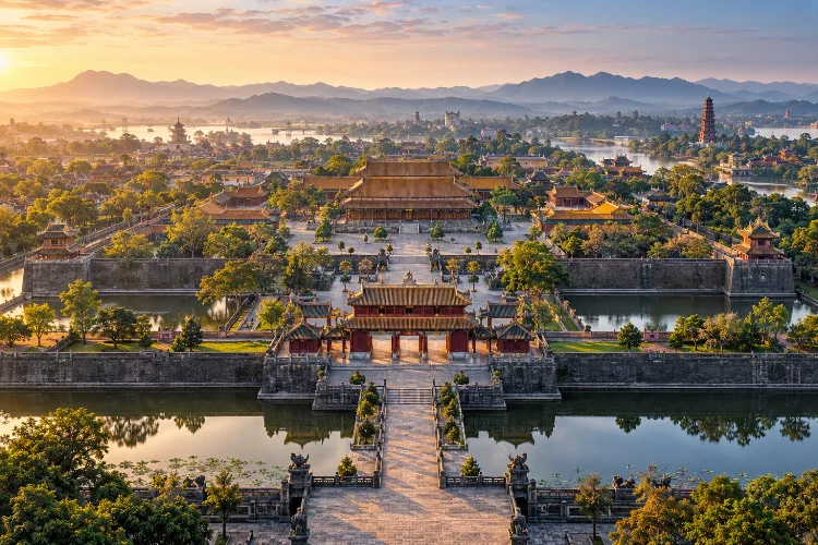
The city became the capital of unified Vietnam in 1802 under the Nguyen dynasty and remained the country’s political, cultural, and religious centre until 1945. Its monumental landscape includes the Capital City, Imperial City, Forbidden Purple City, temples, ceremonial areas, and royal tombs.
Yet the city’s natural surroundings were just as important as its walls.
The Perfume River runs through the historic landscape, while nearby mountains were incorporated into the symbolic design of the capital. UNESCO notes that the city’s plan reflected traditional Eastern philosophy while adapting to the physical conditions of the site.
Royal architecture was therefore connected to cosmology.
Mountains, rivers, defensive structures, ceremonial spaces, and palace buildings worked together to present the emperor as the centre of an ordered political world.
Walking around Huế today, that relationship between power and landscape remains surprisingly visible.
Luang Prabang Was Both a Royal and Religious Centre
Not every royal capital was dominated by enormous fortified palaces.
Luang Prabang developed at the meeting point of the Mekong and Nam Khan rivers in what is now Laos. From the 14th to the 16th century, it served as the capital of the powerful Lan Xang kingdom, sometimes translated as the Kingdom of a Million Elephants.
Its location supported trade, but religion was equally important.
Buddhist monasteries became essential parts of the urban landscape, while royal residences and religious institutions occupied the historic peninsula. Mount Phousi rises at its centre, creating a strong connection between sacred geography and urban form.
Later colonial buildings were added during the French period, producing an unusual combination of Lao and European architecutre.
That mixture makes Luang Prabang especially interesting.
Rather than representing one dynasty frozen in time, the town reveals how a royal capital can continue changing while preserving earlier cultural layers.
Beijing Turned Imperial Authority Into Monumental Architecture
Few capitals express centralized authority as dramatically as Beijing’s Forbidden City.
Constructed between 1406 and 1420 under the Ming emperor Zhu Di, the imperial complex became the political centre of successive Ming and Qing dynasties. UNESCO records that 14 Ming and 10 Qing emperors were enthroned there over more than five centuries.
The palace was not randomly arranged.
Its sequence of gates, halls, courtyards, residential areas, and ceremonial spaces created an increasingly restricted environment as visitors approached the centre of imperial authority.
Scale mattered.
Architecture reinforced hierarchy by controlling who could enter particular spaces and how people moved through them. Roof forms, colours, platforms, gates, and axes helped communicate the status of the emperor.
This makes Beijing an excellent example of architecture functioning as political language.
The city was designed not only to house government but also to make imperial power physically visible.
Nara Shows How Asian Capitals Borrowed From One Another
Royal capitals rarely developed in cultural isolation.
Nara became Japan’s capital in 710 and remained so until 784. During this relatively short period, the Japanese state consolidated important government institutions while absorbing influences from the Asian mainland.
UNESCO notes that Nara’s palace layout and surviving monuments provide outstanding examples of early Asian capital planning. Cultural connections with China and Korea strongly influenced Japanese architecture and art during this period.
This is an important reminder when tracing historic capitals.
Political ideas travelled.
City grids, Buddhist institutions, administrative practices, writing systems, architectural styles, and court culture could move between kingdoms through diplomats, monks, scholars, merchants, and migration.
However, borrowed ideas rarely remained unchanged.
Japan adapted continental planning traditions to its own political and religious enviroment, creating a capital that reflected both international connections and developing local identity.
Kyoto Turned a Royal Capital Into a Cultural Centre
In 794, Japan established another capital at Heian-kyo, the city now known as Kyoto.
Like Nara, its original design drew inspiration from ancient Chinese capital planning. Kyoto remained Japan’s imperial capital until the middle of the 19th century and became one of the country’s most influential cultural centres.
Its importance extended far beyond the imperial palace.
Temples, aristocratic residences, gardens, craft districts, religious institutions, and later samurai culture contributed to a highly layered urban identity.
UNESCO describes Kyoto as the centre of Japanese culture for more than 1,000 years and highlights its enormous influence on wooden architecture and garden design.
This illustrates something important about long-lived capitals.
Political authority attracts artists, scholars, religious institutions, craftsmen, and wealthy patrons. Even when political power later shifts elsewhere, the cultural ecosystem created around the court can survive.
Kyoto’s royal role declined, but its cultural influence did not.
Gyeongju Reveals the Cultural World of the Silla Dynasty
In Korea, Gyeongju offers another model of a historic royal capital.
The city was closely associated with the Silla dynasty, which ruled for almost a millennium, from 57 BCE until 935 CE. The surviving historic areas include palace remains, royal burial mounds, fortifications, Buddhist temples, sculptures, and archaeological sites.
These remains reveal how royal and religious landscapes became intertwined.
Buddhism gained enormous importance within Silla political culture, and religious monuments helped express the dynasty’s wealth, legitimacy, and cultural sophistication.
Royal tombs provide another dimension.
Instead of examining only palaces where rulers lived, visitors can study burial landscapes to understand how elites represented status after death.
Gyeongju therefore demonstrates why tracing royal capitals requires looking beyond palace walls. Cemeteries, temples, mountains, roads, and defensive sites can be just as revealing as official residences.
Why Asian Kingdoms Moved Their Capitals
A capital might seem permanent, especially when rulers invest enormous resources in walls, palaces, and temples. Historically, however, capitals moved surprisingly often.
Military threats could make an older location vulnerable. Trade networks might shift, making another city economically more useful. Dynastic change could encourage a new ruler to establish a fresh political centre.
Geography also mattered.
Access to rivers, fertile plains, transportation corridors, and defensible terrain could determine whether a capital remained practical.
Sometimes moving the court was also symbolic. A new dynasty could distance itself from previous rulers by constructing a new centre that reflected different political ambitions.
This is why Southeast and East Asia contain so many former royal capitals.
Their abandoned or transformed landscapes are evidence that political geography was constantly evolving rather than remaining fixed.
How to Explore a Former Royal Capital Today
The easiest mistake is visiting only the palace.
A better approach is to examine the entire urban system. Start by identifying rivers, defensive walls, major roads, religious compounds, royal tombs, markets, and historic residential areas.
Then consider how they relate to one another.
Was the palace located at the geographical centre? Did temples surround it? Were merchants kept in seperate districts? Did the main road lead toward a ceremonial gate?
Even modern streets can preserve traces of older planning.
Historic maps are particularly useful because later development often hides the original scale of royal cities. Comparing past layouts with current neighbourhoods can reveal how deeply former capitals still influence urban life.
Tracing royal capitals across Southeast and East Asia reveals how rulers transformed geography into political power.
Ayutthaya used rivers for trade and defense, Huế connected imperial planning with symbolic landscapes, while Beijing created an extraordinary architectural expression of centralized authority.
Luang Prabang blended kingship with Buddhist traditions, while Nara, Kyoto, and Gyeongju demonstrate how political centres could also become engines of religion, art, architecture, and cultural exchange.
These cities are more than collections of historic monuments. They are surviving maps of how Asian dynasties imagined power.
When exploring a former capital, look beyond the famous palace. Follow the old streets, rivers, temples, defensive lines, and burial grounds. Together, they reveal how an entire royal world once worked.